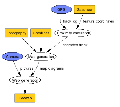
# Data flow diagram

digraph G {
	nodesep=.1;
	ranksep=.3;
	node [height=0.3,fontname="Helvetica",fontsize=10];
	edge [fontname="Helvetica",fontsize=10];

	prox [label = "Proximity calculation"];
	map [label = "Map generation"];
	web [label = "Web generation"];

	node [shape=octagon, style=filled, fillcolor=".64 .54 .99"];
	Camera;
	GPS;

	node [shape=box, style=filled, fillcolor=".13 .9 1"];
	Camera -> web [label = "pictures"];
	GPS -> prox [label = "track log"];
	Gazetteer -> prox [label = "feature coordinates"];
	prox -> map [label="annotated track"];
	Topography -> map;
	Coastlines -> map;
	map -> web [label = "map diagrams"];
	web -> "Geoweb";
}